


Have you ever wonder how the directional tool works, why we need GYRO tool, what magnetic interference is ,etc? It is very difficult to find the answer even though we have internet. Recently, my friend shares me this excellent book, Introduction to Wellbore Positioning by Prof Angus Jamieson at University of the Highlands & Islands. This is one of the best books regarding wellbore positioning. In the book, not only does it have the text, but also contains tons of picture which will help learners to get more understanding of this topic.
What will you learn from the Introduction to Wellbore Positioning?

The contents are as listed below;
- Coordinate Systems and Geodesy
- Changing from One Map System to Another
- True North, Grid North and Convergence
- The Earth’s Magnetic Field
- Principles of MWD and Magnetic Spacing
- In-Field Referencing
- Survey Calculation Methods
- Survey Frequency
- Gyro Surveying
- Basic Gyro Theory
- When to Run Gyros
- Correcting for Sag
- Correcting for Magnetic Interference
- Multi Station Analysis
- Correcting for Pipe and Wireline Stretch
- Human Error v Measurement Uncertainty
- Understanding Error Models
- The ISCWSA Error Models: Introduction
- The ISCWSA Error Models: Explanation and Synthesis
- Anti-collision Techniques
- Planning for Minimum Risk
- Basic Data QC
- Advanced Data QC
- Tortuosity
- Some Guidelines for Best Practice
- Relief Well Drilling
- Subsea Positioning
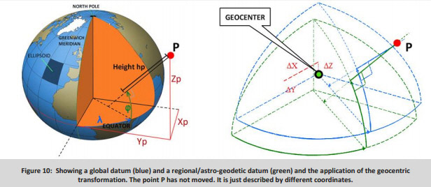
Some of images in this book


Please download from this link –

Updated download link
LATEST VERSION: V06.02.2017
The competency programme in wellbore positioning has been developed by the university with contributions from members of the Industry Steering Committee for Wellbore Survey Accuracy (ISCWSA).
https://www.uhi.ac.uk/en/t4-media/one-web/university/research/eBook_V9_10_2017-redux.pdf
If you think, this would be advantage for your friends, please feel free to share with them.
